Ok folks, the latest EURO is in and it looks likely for 2 things to happen. There appears to be 2 distinct scenarios that will happen…. One will happen late Saturday night in MS, LA, and AL. The other will be Sunday early through the afternoon from Georgia into the Carolinas…. Again, this is way out in advance but it is looking likely from both the GFS and EURO that this will be a 2 day type of scenario (I don’t want to call it an event, that is a scary word) that will be interesting to watch develop over the next few days. Lets start at 7pm at 500mb (20,000ft above the ground) and check out what is going on.
The next three images are the shortwave as it is projected to eject out of TX and LA late Saturday afternoon. Notice as it moves through the SE United States it goes from a NE to SW orientation to a NW to SE orientation as it moves through time. That is called a negatively tilting shortwave and usually, not always, those can produce some pretty strong storms… Again as my mentor in college Dr. Chuck Doswell used to always tell me, this doesn’t mean that we WILL have severe weather… It only means that there is another ingredient to watch .. This is for Sunday 7am, 1pm, then 7pm.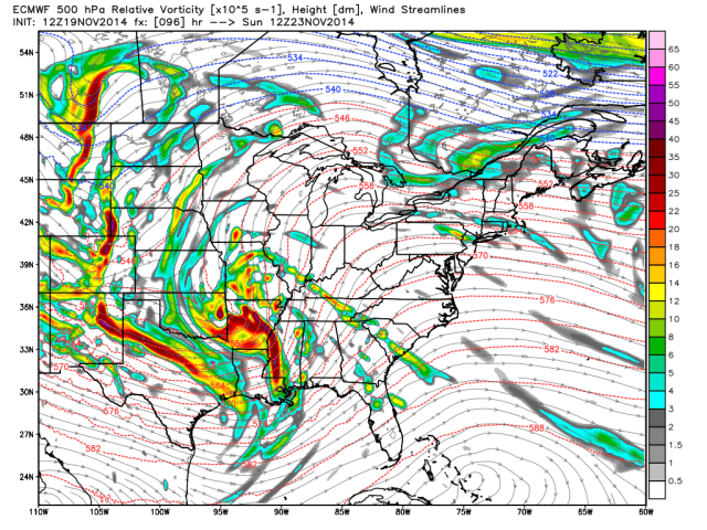
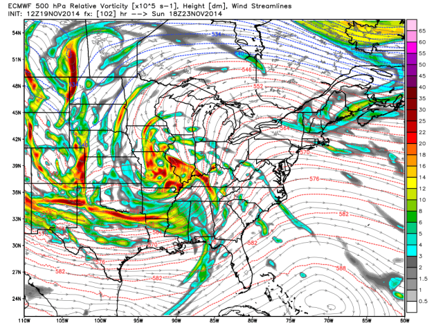
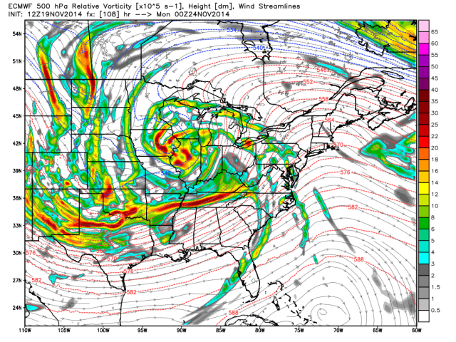
And again, there is a lot of energy behind the system. It has slowed down a bit on the latest run and I don’t want you to get stuck in the timing details, but it looks mainly like sometime Sunday morning for us here in Georgia.
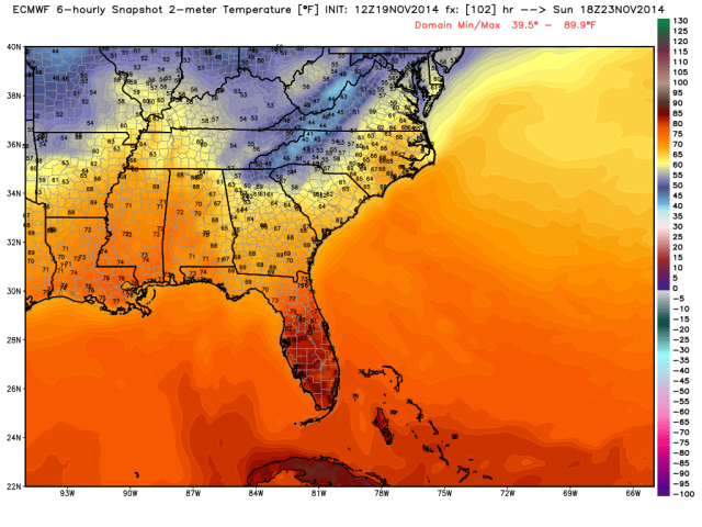
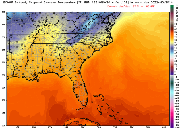
Down to the surface for the temps we can see again the wedge holding strong for the majority of Saturday, but then as this system kicks out Sunday during the morning hours watch as the warm air slowly, then quickly pushes the cold air out of here. It is a monumental task to push a wedge like this one out and it is along the strongest contrast between the cold and warm air that we will have to watch closely as this system develops. Here are the images of the surface temps at 7am, 1pm, and 7pm. Notice how we go from the 30’s and 40’s into the upper 60’s in just a few hours! It is along this change in temp that the strongest storms will be located.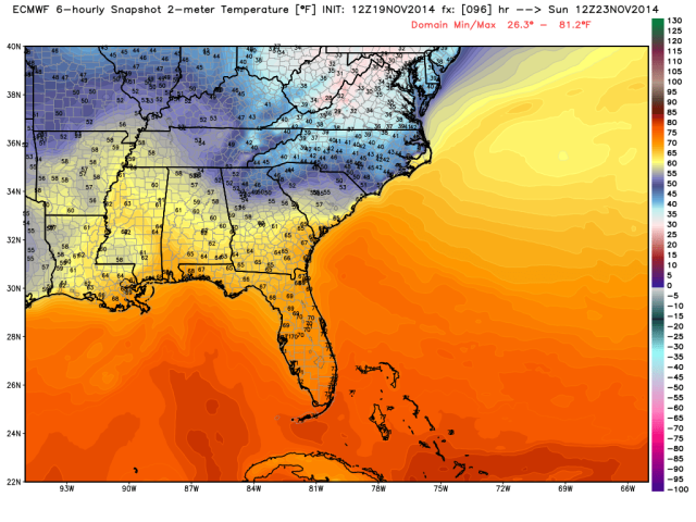
The latest from the EURO for the rain and pressure show a very intense low that develops in Oklahoma and moves into and through Arkansas, then up through Missouri… Ahead of the low there will be very strong winds all day before the storms, and after the storms. We could see wind gusts on Sunday not in storms up to 30mph+. Here is the system at the surface as it moves through Sunday morning through Sunday evening. This is for Sunday at 7am and 7pm. 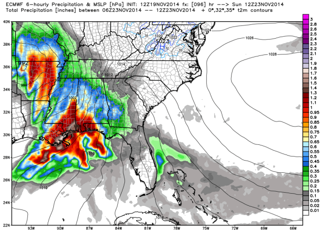
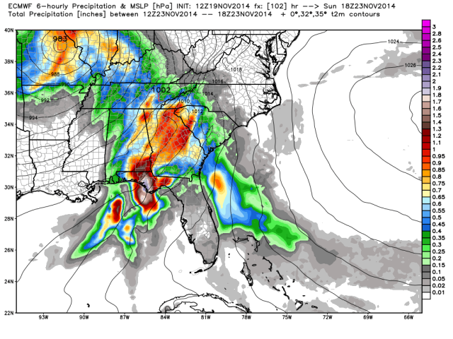
This scenario is showing the storms moving through mid to late morning across the N Georgia area…. One thing that could be promising in this latest run is the complex of storms that could develop in the Panhandle region. If this system down to our south gets huge late Saturday night into Sunday morning it could squelch severe weather chances here… Time and more runs will tell.
Again, the timing on this is still very much iffy and will be changing over the next few days. Right not I am thinking about a 2 on a scale of 1-10 with the option to increase that level as the more refined models pick up on this system.
Stay tuned and you can always get on the e-mailing list that I talk about down below.
As most of you know, my days on the tube are a thing of the past, but I will keep my extreme love for the weather alive through my blog and social media presence. I am now in the business of real estate so if you would like to support this blog and my “hobby” of weather. I am going to start a daily forecast for everyone who would like one delivered to their inbox every morning. Go to my website by clicking here and register. Yes it is my real estate site, but I won’t put you into the real estate part of it, I will put you in as “weather geek” and you will just get my weather stuff with an occasional non weather email, don’t be scared I won’t spam you with marketing stuff. Thanks again for all of your support!!
Thanks as always for your continued support!! You guys are the best!!!
